- UNITS
- Unit 9 - The Earth Grid's System
- The Game of Words
- Prof. Xue and Luk's Conversation
- An Active Reader
- Asking Questions
- Language Knots
- Test Corner
- LEARNING
♦ This introductory exercise aims to give you a feel for the sound and rhythm of the language, whilst presenting an overview of the maritime topic at hand. ♦ By reading and then listening to the accompanying audio, you’ll discover how words are pronounced and some simple sentence structures. ♦ Once you are comfortable with how the written and spoken words are connected, you’ll be ready to focus on keywords in the next exercise.
The Earth Grid’s System
We had a short run through marine History, now we focus on Geography. It is an essential thing to study for a life in commercial shipping.
The word Geography was first used around 200 BC by a Greek scholar. The word combines the Greek ‘geo’ - Earth and ‘graphein’ - to write, so it’s a written study of the Earth. The modern study of Geography can be split into two parts: physical geography and human geography.
Physical geography is the study of the dynamics of nature and the environment around us: the mountains, rivers, oceans, plants, and weather. Human geography is the study of human activity and how it affects Earth’s surface, it focuses on human populations, languages, economic and political systems, urban and rural living.
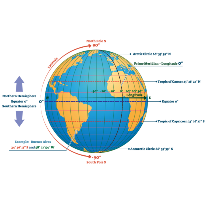
Map-making, or cartography, has always been an extremely important aspect of Geography. This is especially for seafaring people, as there are no roads, signs, and people to point you the right way on the world’s oceans. Maps help define location. Firstly, there is ‘relative location’, which is how far a place is from another place. Secondly, there is ‘absolute location’, this is exactly where a place on the Earth is. Absolute location relies on longitude and latitude.
Longitude and latitude are imaginary lines that split the sphere of the Earth up into 360 degrees, East-West and North-South. This creates a grid pattern, called the graticule, which allows geographers to accurately locate any place on Earth. The primary line of latitude is around the Earth’s horizontal center, it’s called the Equator. All of the other lines of latitude are parallel to the Equator, they end at 90 degrees North and 90 degrees South at the two poles. The two next most important parallels are the Tropics of Cancer and Capricorn, the area between them is the tropical zone, above and below are the temperate zones. Above this is the Arctic Circle and below is the Antarctic Circle.
The primary line of longitude runs North-South through the Royal Observatory in Greenwich, London, England. It divides the Earth into Eastern and Western hemispheres. The Eastern Hemisphere includes the continents of Europe, Asia, and Australia, it runs from 0 degrees to 180 degrees finishing at the International Date Line. The Western Hemisphere covers the other side and includes North and South America.
The world’s time zones are also based around lines of longitude. Coordinated Universal Time (UTC), Greenwich Mean Time (GMT) is the time zone at the prime meridian. There are 24 other major time zones around the world, all on North-South lines of longitude. They sometimes bend round the borders of countries and islands. UTC is a 0-24 hour global time. It’s the same everywhere, regardless of day or night. UTC is used by pilots, sailors, and international radio-broadcasters so that they can work together around the world.